
Find the pad. Balance the dirt.
Plan > Manufacturing pulls one meter USGS lidar for your tract, searches pad locations for the least earthwork, and computes cut and fill on two meter cells with slopes to daylight. Change the pad level and the quantities move with it. Type your own unit prices and the earthwork prices itself.
How cut and fill works in Plan
Each chapter of the video above, in the order you would use it. Click a chapter to jump to it.
- Free
0:00 Open the tract in Plan
Pick a tract and choose Manufacturing. Flat acres and the ground section are on every plan.
- Pro
0:08 Lidar pad search
Plan pulls the USGS 3DEP lidar for the tract, tries pad locations across it and keeps the one that moves the least dirt.
- Pro
0:17 The ground model
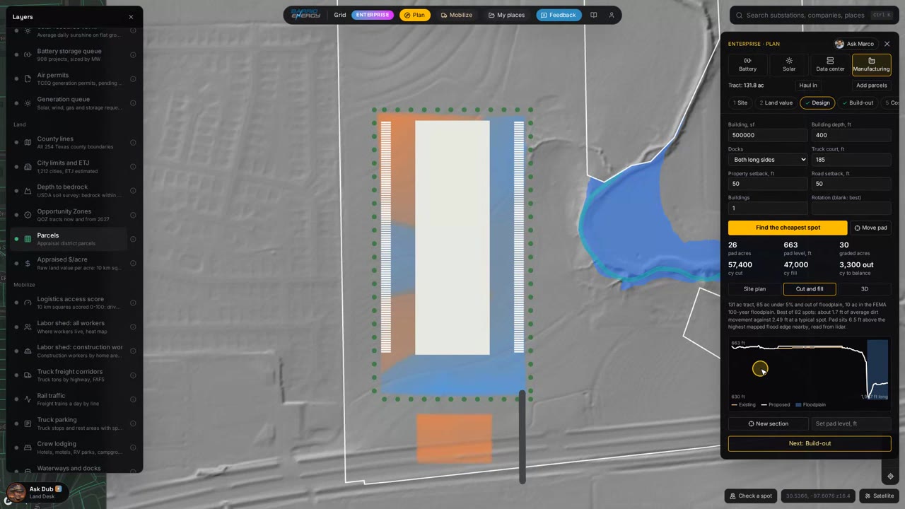
One meter lidar elevation points across the tract, with the relief under the pad.
- Pro
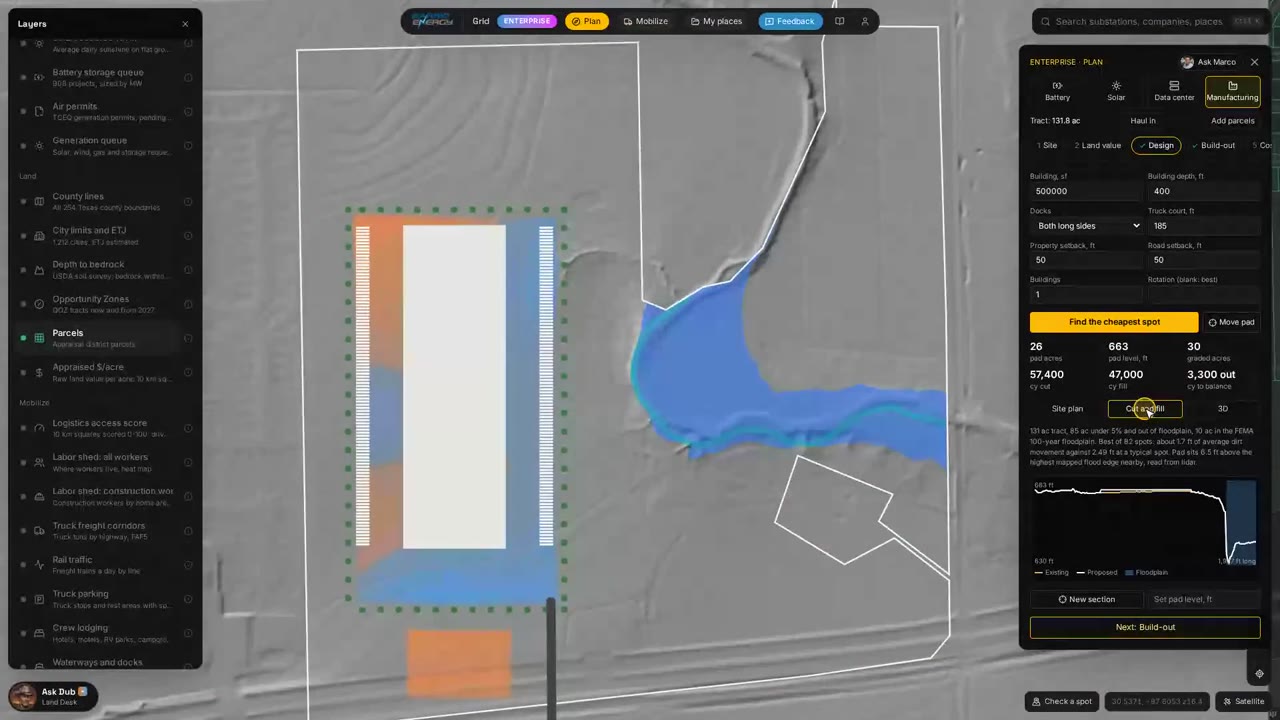
0:32 Cut, fill and volumes
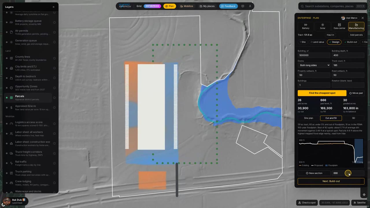
Orange is cut, blue is fill. Volumes come from lidar ground minus finished grade on a two meter grid, with 3:1 slopes out to daylight.
- Free
0:59 The section
Existing ground against the finished pad, in profile.
- Pro
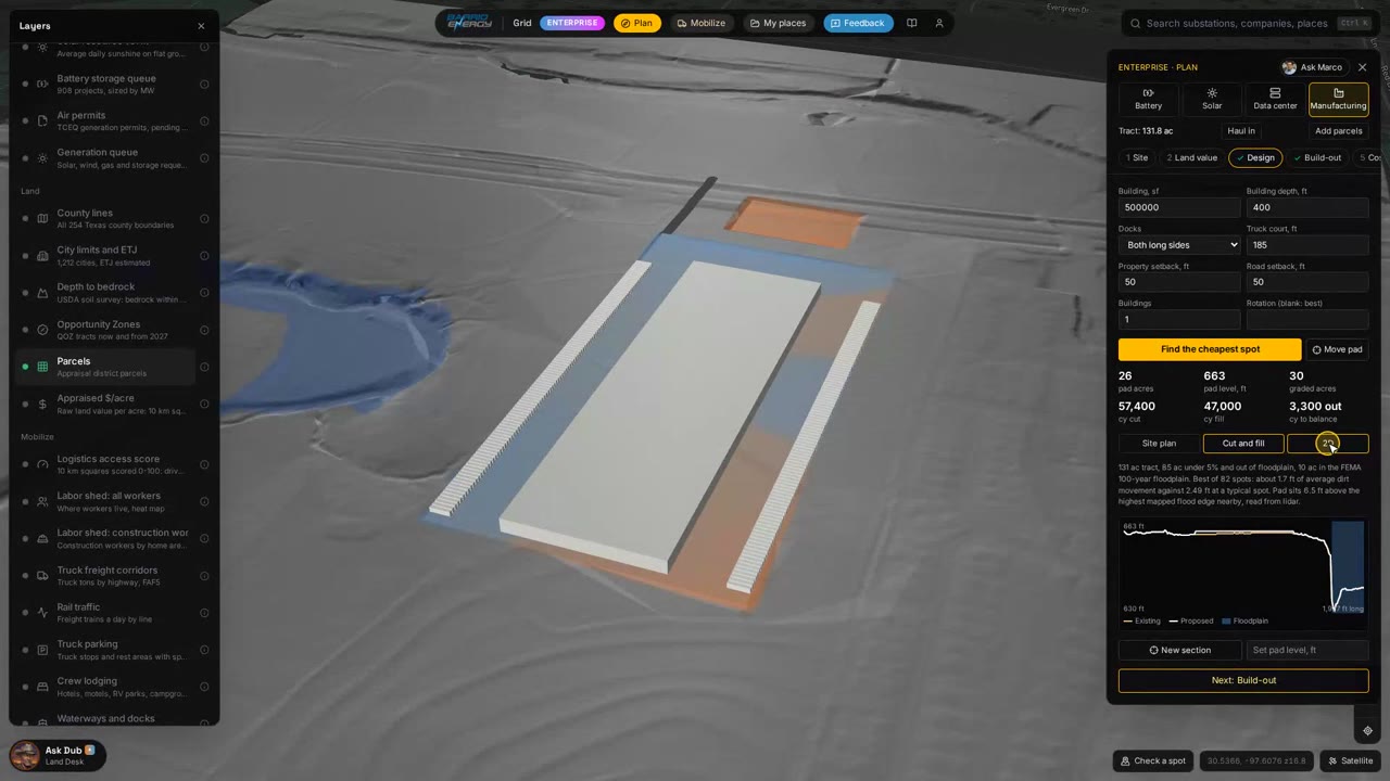
1:09 3D and the balanced pad
The surface in 3D with the totals. Fill gets 15 percent shrink, and the pad is set where the cut covers it, with any extra to haul off.
- Pro
1:36 Raise the pad
Set a different pad level and cut, fill and import or export update at once.
- Pro
1:57 Your unit prices
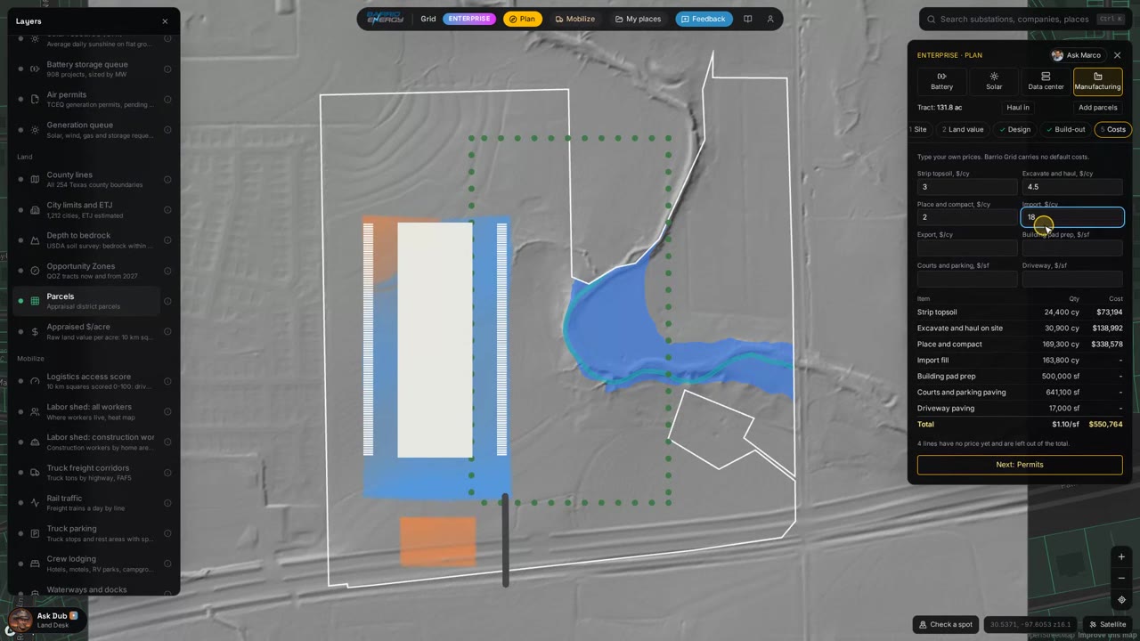
Type your own unit prices. There are no default costs; the total is built from yours.
How a pad plan runs on Barrio Grid
Each step is a panel on the map or a tool your AI assistant can call through the connector.
- Free
Find the land
Ask Dub for flat acres out of the floodplain near a highway, or draw your own tract.
- Pro
Open Plan > Manufacturing
Set the building size. Plan pulls the lidar and searches for the pad that moves the least dirt.
- Pro
Balance the site
Read cut, fill and shrink, then move the pad level until the dirt balances or the import is one you can live with.
- Pro
Price it
Enter your contractor's unit prices and the earthwork total follows.
- Pro
Lay out the site
Building size and depth, truck courts and trailer stalls, car parking, fire lanes and driveways. Several buildings on one tract are on Enterprise.
- Pro
Check the permits
Run the Permit Plan for manufacturing at the same spot to see what each agency requires. How the Permit Plan works.
What you get back
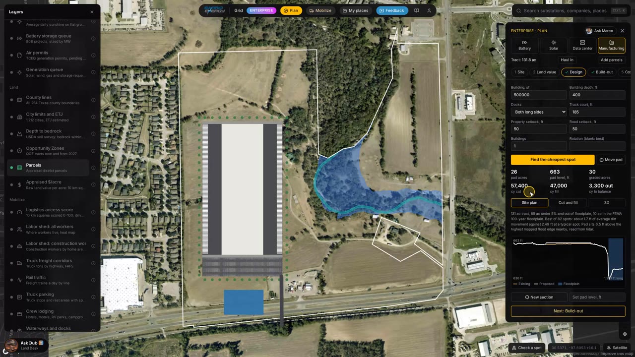
Cut and fill questions
Where does the ground model come from?
USGS 3DEP lidar, one meter resolution where it is published, which covers most of Texas. Volumes are computed on two meter cells.
How is the pad level set?
Ground above finished grade is cut and ground below is fill. Fill gets 15 percent shrink, and the pad is set where the cut covers the fill. You can move it up or down yourself.
Where do the costs come from?
From you. Plan has no default earthwork prices. Enter your own unit prices for topsoil strip, excavation, fill placement, import, export, pad prep, paving and driveways, and the total is built from them.
Can I build from these quantities?
No. They come from lidar and are for screening and comparing tracts. Detention is a placeholder share, and soils, clearing and road grading are not in the quantities. Confirm with your civil engineer and a survey.
Can my AI assistant use this?
Yes. Barrio Grid is an MCP connector: add https://grid.barrioenergy.com/mcp to Claude or any assistant that supports MCP and ask in plain English. Setup is on the API and MCP page.
Open the map and plan a pad.
Flat acres and the section are free. Pad search, earthwork and your own costs are on Pro: $499 a month, first month $249. Several buildings on one tract are on Enterprise.